Tosohatchee's Historic Buildings and Ruins
The Tosohatchee Wildlife Management Area use to have a lot
of old buildings. Some dating as far back as
the early 1900s. Unfortunately a lot of them were destroyed by fires or
they
just simply collapsed over time. This page attempts to document their
locations and provide some of the history behind them. It's an on going
effort so please check back later for any updates.
Hoot Owl Inn
This is the infamous Grim Reaper's
home or Hoot Owl Inn before it was bulldozed away. It used to be
located off the Florida
Trail near St. Nicholas Road and Tosohatchee Creek near coordinates
N28º 30.814 W80º 58.692. One of the park staff members used
it as a storage shed which explains all the junk that was found inside
of it.1


Turkey Cabin
Turkey Cabin most likely got its name from the 100's of
turkey claws that were hammered to the interior walls. It had all the
creature comforts you could ask for -- a gas range,
generator, hot water heater and a flushing toilet. There was even
running water piped in from an artesian well. Hikers would come in from
nearby Tiger Branch campsite and get water from a hose out back and
shower up. This continued until one day a high official from from
Tallahassee had the trail spur leading to the camp closed so he
wouldn't be disturbed by hikers.2
This is what Turkey Camp looked like before a wild fire
destroyed it. The building was located along Fish Hole Road
at coordinates N28º 28.666 W80º 57.431.


This is what Turkey Camp looked liked several years after
the fire. I'm not sure when it burned down, but I do remember it was
caused by a wild fire during Charlie Matthews tenure as Park Manager at
Tosohatchee. He told me a hot ember must have blown inside and lit the
place up. As
you can see from the pictures, the fire left very little standing. You
can still see the foundation, the metal roof, the water heater and the
old gas
stove.



Interestingly there are two well water test sites nearby
which appear to
have been put in after the fire. Both had St. Johns Water Management
District ID
numbers on them. There's also an older well covered with bricks with no
ID. This
might be the artesian well mentioned earlier. According to a USGS
ground-water report, one well is 120
ft deep and the other two go down 17 ft.


I looked around for anything that might date the structure
but didn't find
anything. Someone, I believe it might have been Charlie, told me it was
built as
a hunting lodge during the 1950s. Too bad it had to go up in smoke.
Bumby Camp or Camp Blanton
Is it called the Bumby Camp or Camp Blanton? The park staff
refer to it as the Bumby Camp, but on George McCulloch's map,
it's known as Camp Blanton. Both appear to be located in the same area
along Jim Creek south of SR 528 at coordinates N28º 26.696
W80º 56.981.

I'm not sure when or how it burned down, but you can still
find plenty of remnants of the old hunt camp including a brick chimney,
several rusted out appliances, car parts, lots of bottles, bed springs
and an artesian well capped off with a valve.

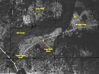
A 1939 aerial map shows something was in that area, but no
obvious roads except for Taylor Creek Road way off to the west. On
the1947 aerial map you can start seeing more of a road or a trail
winding along Jim Creek towards the camp. By 1958 the new improved Long
Bluff Road was put in with a side road going towards the camp. This
aerial image clearly shows the Bumby Camp still standing.


Beehead Ranch
The Beehead Ranch was still active when the State purchased
Tosohatchee back in 1977. Most of the structures were functional at
that time, but over the years they eventually fell down except for one.
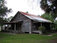
The Beehead Ranch House, which was built back in 1914 by Syndey O.
Chase near coordinates N28º 29.724 W80º 56.410, was
one of the lucky ones. In 1993 it was relocated to the Fort
Christmas Historical Park where it's now on display.

To the south of the Beehead Ranch House near coordinates N28º
29.630 W80º 56.366 was a bunkhouse made out of logs, also
known as the log cabin on George
McCulloch's map. I'm not sure what happened to it.
The structure may have been removed when the Ranch House was relocated.
The only remains I could find were some of the old logs, chicken wire,
part of the roof and a crushed barrel.


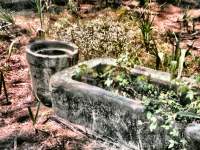
There was a larger barn with stables located at coordinates N28º
29.581 W80º 56.369. It had an artesian well out back that
flowed from a ceramic pipe and into a concrete water trough. This
provided continuous fresh water for the livestock. Also close
by was a cattle dipping vat that was used to eradicate fever
ticks during the early 1900s.


A corral with another dipping vat was located at coordinates
N28º 29.440 W80º 56.395. A lot of the fencing is
still visible today.


If you look at the aerial maps from the 1940s and 50s, you
can clearly see the pasture for the Beehead Ranch along Jim Creek.
Since the closing of the ranch and removal of some of the dikes, this
area is quickly returning back to its former state.


George
McCulloch's map shows some other interesting items in the
Beehead Ranch area. For example, there's a "rock" identified on the map
just north of the "log cabin". I'm not sure what that's all
about. Also there's a "mule pen" just outside the fenced in
area to the southwest at coordinates N28º 29.171 W80º 56.791.

Bottle Camp
According to George
McCulloch's map there use to be a place called Bottle Camp
located near coordinates N28º 30.469 W80º 57.255. A
search of the area did not reveal any sign of a structure but I did
notice that a lot of cows frequent this area. It's as if their instinct
to return to a particular spot is passed down from one cow generation
to another. Who knows. This might have been where they were fed and
corralled many years ago.

Fish Holes Camp
According to a story written by Joan Chase
Hargadon and published in
Carl Patterson's Windermere Among the Lakes book, there was a camp
located just
east of the confluence of 3 creeks: First, Second and Tosohatchee
Creek. I
really believe she meant Jim, Second and Settlement, since Tosohatchee
Creek
doesn't come close to Second Creek and there is no First
Creek. But
Jim, Second and Settlement Creeks do join together near Fish Hole Road.
A search around this area near coordinates N28º
27.480 W80º 56.806 revealed some interesting finds. For
example there is a 7 foot pole covered with nails still standing near
the creek. Most of the surrounding palm trees had rusty nails still
sticking out of them as if may be they were used to tie off a tent or a
hammock. Unfortunately the flooding of the creek has probably removed
all other evidence of the camp. I did however find a couple whiskey
bottles dated 1959 but they could have been washed down from somewhere
else.
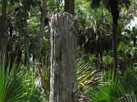

According to
George McCulloch's map of Tosohatchee, there was a
camp called Fish Holes Camp located in this very spot. The map shoes
several
trails converging into this one location. A detailed 1920s St. Johns
Drainage
District survey map also shows these trails. Both maps give
us a good idea where
to look for the camp.


Walt's Camp
The name of this camp was a mystery for the longest time
until I got a hold of
George McCulloch's map. It shows a place called Walt's Camp
with a little fence around it just south of Second Creek and SR 528
near the edge of Tosohatchee at coordinates N28º 26.991 W80º
57.682.

Remnants of the old fence can still be found as well as some
rusty appliances and foundation stones with interesting bird prints on
them..


Old bottles and broken china date the area to be around the
1950s, but aerial maps from the late 1930s and 40s show this
place being used back then.


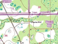
According to a USGS
topographical map from the 1950s, there was a flowing well
right next to the camp. A search of the area only revealed a dry
shallow swale running back towards Second Creek. It could have been
created by the well when it was in operation.
Joe Camp
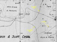
Joe Camp has not been found yet. According to a 1920 St. Johns Drainage
District survey map, there was a house located at
coordinates N28º 27.331 W80º 55.871 which
would put it right smack dab in the middle of Long Bluff Road about a
1/4 mile northeast of the SR 528 underpass. On George McCulloch's map,
it's more to the east at around coordinates N28º 27.316 W80º
55.538. Hopefully the remains are still out there some place
just waiting to be found.

Department of Natural Resources Building
For some reason the Department of Natural Resources decided
to build a block house south of SR 528 near the intersection of Spur
Road and Long Bluff
Road at coordinates N28º 26.572 W80º 57.004. There
wasn't much inside of
it -- only a sink and a bench with some sort of ventilation conduit
pipe coming
down from the ceiling. A water tank was also mounted on the outside of
the
building. Sometime ago a wild fire destroyed the roof and everything
inside was torched.


Nearby hidden among the palmettos at coordinates
N28º 26.561 W80º 57.009 is
an old fire truck rusting away. It was caught in the flames of a much
earlier
wild fire and had to be abandoned.3

Streetman Cabin
The Streetman Cabin was located on Long Bluff near the St.
Johns River at coordinates N28º 29.382 W80º 52.958.
A fellow by the name of J.A. Streetman and his wife Verlie use to live
in the cabin. Mr. Streetman was the game warden for 7 years at the
Tosohatchee Game Preserve.4
George
McCulloch's map shows the structure with a fence around it
and the Long Bluff Trail leading to it. A 1951 aerial map
shows the new improved Long Bluff Road ending at Long Bluff. Later the
Department of Natural Resources closed off this section of Long Bluff
Road and rerouted the road to the power lines further north so it
wouldn't impact an Indian midden.5


Taylor Creek Ranch
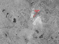
I wasn't sure what to call this place. It's located south of
SR 520 along the white blazed trail loop at coordinates N28º
22.229 W80º 54.394. It's not that far from Taylor Creek,
hence the name. If you look at the 1943 and 1951 aerial maps below you
can clearly see the boundaries of the ranch. Since SR 520 wasn't built
until 1956, people had to come in from Taylor Creek Road to get to the
ranch. The double-tracked white blazed trail follows a portion of that
route before it makes a sharp left turn and heads towards Taylor Creek
Slough.
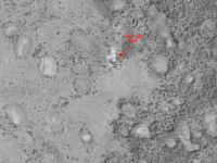
A 12x16 foot concrete slab, a crumpled-up tin
roof, a 3-basin sink and
some other fire resistant objects can be found in the area.


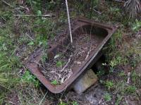
There's also a dipping vat nearby and an artesian well with
a bathtub sitting right next to it. Now I know how those old timers
took their baths. Actually the tub along with the artesian well were
more likely used to fill the dipping vat with water.


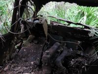
Way in the back hidden in the palmettos at coordinates N28º
22.226 W80º 54.319 is the rusted remains of an International
Harvester Metro Van. They were manufactured between 1938 and 1984. This
particular model was probably built in the 1940s or 50s.


Foot
Notes
- Information on the contents of Hoot Owl Inn was provided by
Doug Sphar.
- Information about the turkey claws and the use of the
artesian well at the Turkey Cabin were provided by Doug Sphar.
- Information about the fire truck was provided by Ed Harris.
- Information found in the Fort Christmas - A Pictorial
History book by the Fort Christmas Historical Society.
- Information about the rerouting and the closure of Long
Bluff Road was provided by Doug Sphar.
Last
updated on 5-Sep-2009


